Google tools for cultural
Cultural and heritage organizations might entice people to visit by using a variety of Google tools. Andy Wolber highlights four tools you should consider.
In the United States, people made more than 1.6 billion "person-trips" for leisure in 2013, according to the U.S. Travel Association. On these trips, we visit family and friends, shop, and dine. A smart retailer or restaurateur makes sure their business can be found quickly with a smartphone search.
Three out of four leisure travelers also pursue cultural activities when traveling: we visit a museum, enjoy a live performance, or tour a historic site. Cultural organizations and historic sites need to be as easy to find as shops and restaurants. These days, that means creating aGoogle+ local page, a Facebook local business page, and a Foursquare listing.
But cultural destinations can do more than just list location, hours, and program information on social media sites. Here are four Google tools that allow cultural organizations to engage visitors visually online.
1. Google Earth
Google Earth offers a satellite view of a location -- similar to the satellite view you've likely seen on a Google Map. However, Google Earth adds layers and flying sequences ( Figure A). You can select check boxes to display or hide roads, 3D buildings, weather, or photo layers on the map. Select a series of sites, then record a tour.
Figure A
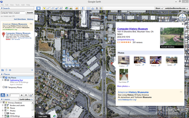
Install Google Earth to view multiple map layers or create virtual flying tours.
Google Earth works well for limited audiences: people who have Google Earth installed who are also willing (and able) to open Google Earth files. For educators or historians, Google Earth makes it easy to create and share maps. Some tourism promoters create and share videos of destinations, such as the video below: "Florence Virtual Tour: Churches and Museum (Google Earth)." The videos are widely accessible; the actual Google Earth files are not.
2. TourBuilder
TourBuilder, a beta project, brings a virtual tour to Windows or Mac browsers with a plugin (Figure B). As a result, viewers only have to install a plugin to view the files. TourBuilder projects are therefore a bit more "shareable" than Google Earth tours, although the tours won't display on Chromebooks or mobile devices.
Figure B

TourBuilder enables virtual tours in browsers on Mac and Windows devices with a plugin.
Each tour location displays the map site, along with descriptive text to the side. Multiple photos may also be added above the descriptive text. Technology historians might enjoy the TCP/IP tour, created by Bill Daul, which includes 14 sites where historical events related to the protocol's development occurred.
3. Google Views
The Google Views site features photo spheres around the world. These immersive photos display 360 degree images of historic sites and scenic views (Figure C). Search for popular tourist destinations, and you'll likely find several images. Even better, Views display on mobile devices.
Figure C
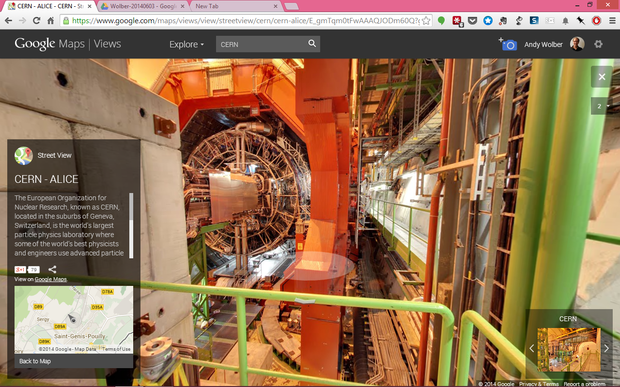
Google Map Views offer 360 degree images of places around the world, including CERN.
If you have an Android phone, install Google's Camera app to create your own photo spheres. Essentially, you select "VR Panorama" mode, hold your phone vertically (in portrait orientation), then proceed to take a series of photos while turning slowly in a circle. Hold your phone as steady as possible to avoid odd "seams" when the images are "stitched" together. The app displays target locations to ensure you capture the entire scene.
Google also partners with photographers to create "Business Views," which are 360 degree interior images. Tourist destinations may find that a business view encourages visitors: it shows exactly what the interior of a shop, restaurant, or other location looks like (Figure D). The Views show alongside your organization's information on Google Maps, Search, and on Google+.
Figure D
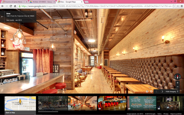
Brew, a coffee shop in Traverse City, Michigan, used Business View to show their interior.
4. Google Open Gallery Project
Part of Google's broader Cultural Institute, Open Gallery, allows museums, artists, and galleries to share images from their collection (Figure E).
The tool provides a visually compelling way to present high-resolution images of cultural objects such as painting, documents, or photographs. Each object is displayed along with a description, and some other "meta data" about the object (i.e., the creator's name, year created, location, collection, etc.).
Visitors to the Cultural Institute Art Project may create their own galleries of images. For example, a Michigan history fan might add the 8 paintings by Frederick Frieseke found in the collection to their personal "gallery." Frieseke graduated from high school in the town of Owosso, Michigan. An organization must request an invitation to upload and share images from their collection.
Figure E
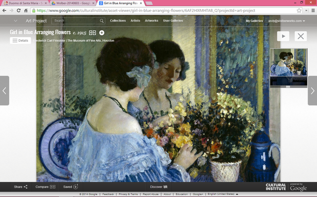
Open Gallery offers cultural collections a visually compelling way to share high-resolution images online.
Open Gallery doesn't replace a museum collections management system. Think of it as an outreach and promotion tool to entice cultural tourists to visit your collection.
In a way, I think all of these tools are intended to both guide and inspire. Maps have always included images to represent territory. But, as Alfred Korzybski said, "the map is not the territory."
All of these tools offer us images, but we must realize that viewing images virtually does not replace the experience of direct engagement -- of art works, ideas, and people -- outside the familiar red Google map pin we each call "Home."
Which Google tools do you use when you travel? Share your experience in the discussion thread below.


0 comments:
Post a Comment